Surface Parcel Mapping
Appalachian & Mid-Continent Basins
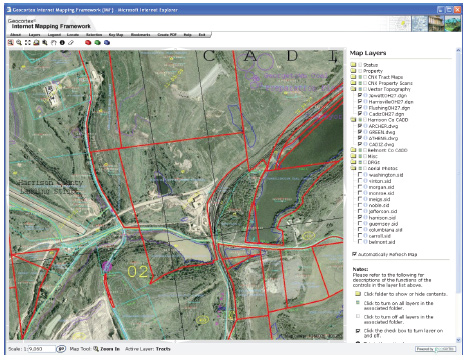
Mr. Seifarth managed a contract to map all of CNX Land Resources, Inc. (CNX) held surface parcels. The project entailed nearly 450,000 acres of property in 15 states and one Canadian province with the majority of holdings located in Ohio and West Virginia. The mapping assisted CNX in the evaluation of properties that had commercial value, while providing an accurate, up-to-date representation of holdings. The services included data collection and research; parcel geometry creation, verification and attribution; development of GIS base layers and GIS web viewer application; and preparation metadata and data libraries.
The GIS application was designed and implemented using a surface parcel GIS database that was derived from numerous data sources. The data sources consisted of county tax records, parcel layers, CNX documents and background imagery. The GIS database was designed for eventual integration into a proprietary in-house land management system.
The custom application utilized SQL Server, Arc Internet Mapping Service (ArcIMS), Arc Spatial Data Engine (ArcSDE) and Geo-cortex Internet Mapping Framework (IMF) to provide a solution to data compilation and presentation requirements.
Company: Civil & Environmental Consultants, Inc.
Client: CNX Land Resources, Inc.
Year Performed: 2006-2007